
how it works
Step 1
Sent to us your question

Step 2
Recept our answer
Step 3
Make a plan for your trip
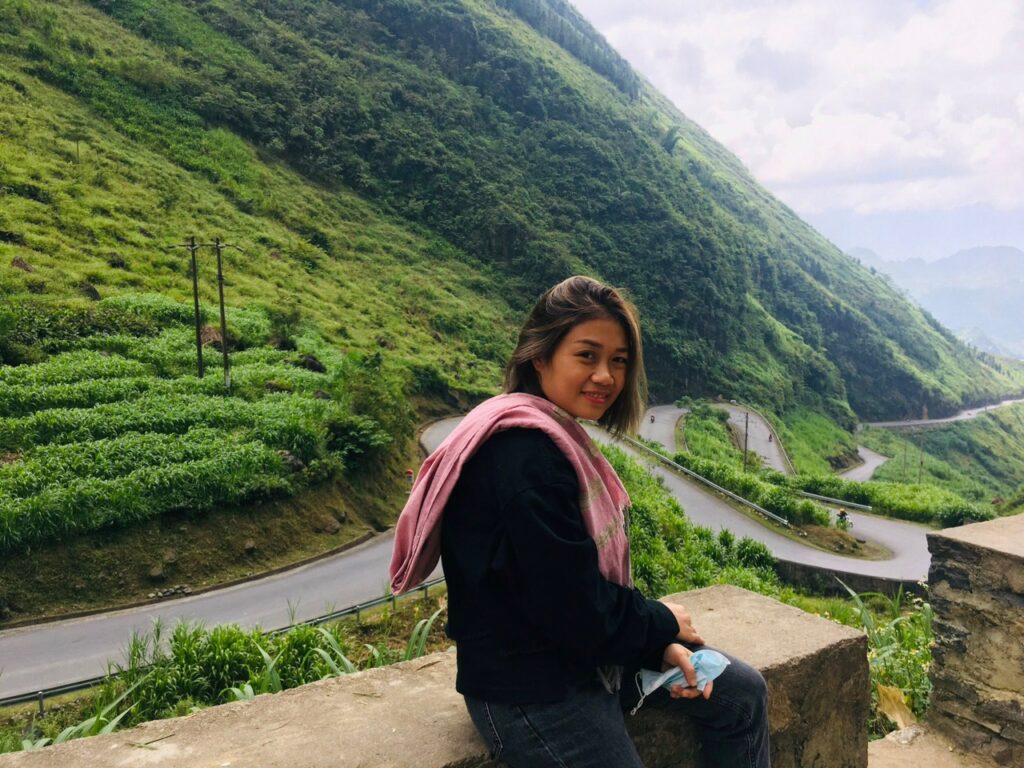
Introducing Cao Bằng
As a mountainous province in the Northeast of Vietnam, where the Vietnamese revolution originated, Cao Bang City is making efforts to overcome difficulties, develop socioeconomic, tourism, and improve people’s living standards.
General Introduction About Cao Bang Viet Nam
Cao Bang Province is a province in the Northeast region of Vietnam. The province borders Tuyen Quang and Ha Giang to the west, and Beijing and Lang Son to the south. It also shares an international border with the People’s Republic of China’s Guangxi province.
Geography
Cao Bang is located in the Northeast of Vietnam. The North and the Northeast are bordered by Guangxi Province (China) with a border length of 333,403 km. Cao Bang province borders Ha Giang, Xuan Quang, Bac Can, and Lang Son provinces in Vietnam. 80 km north-south, 23°07’12” – 22°21’21” north latitude (from Trong Con commune, Thach An district to Duc Hanh commune, Bao Lam district). The length of East-West is 170km, with a longitude of 105°16’15” – 106°50’25” (from Quang Lam commune, Bao Lam district to Ly Quoc commune, Ha Lang district) is 170km.
Cao Bang has a natural area of 6,690.72km², is a plateau of limestone and soil, the average altitude is over 200 meters, and the border area is 600-1300 meters above sea level. Forest area accounts for more than 90% of the province’s area.
The province is divided into three distinct regions: the east is mainly rocky, the west is limestone and mountainous, and the southwest is mountainous and dense. There are two big rivers, the Gan River in the west and the Bang River in the center, and the east flows through the province. There are also some other rivers such as Quy Son, Bac Vong, Nho Que, Nang River, or Hien River.
Gaoping has a mild climate. Summer here is hot and humid, the average high temperature is 30-32°C, and the average low temperature is 23-25°C, in some places it does not exceed 39-40°C.
In winter, Cao Bang is a windy and temperate climate, with an average low temperature of 5-8°C and an average high temperature of 15-28°C. Autumn and spring are indeterminate, and the weather is erratic, spring is often monsoonal, and autumn is pleasantly cool.
History
The provinces of Cao Bang and Lang Son were Quang Nguyen provinces during the Ly Tran dynasty. Quang Nguyen (Lang Son and Cao Bang) officially became part of Dai Viet in 1039 when Nung Tri Cao was expelled under King Ly Thai Dong. After the fall of Thang Long citadel in 1592, the Mac dynasty fled to Cao Bang until 1677, when they established a land against Le-Trinh.
On December 27, 1975, Cao Bang and Lang Son provinces merged into Cao Bang Province. On December 29, 1978, according to the resolution of the fourth session of the 6th National Assembly, Cao Bang was re-established from Koh Lang province, and Yinshan and Cho La districts of Northern Thailand were merged into Cao Bang. At that time, Cao Bang was divided into Cao Bang town and 11 districts.
Population
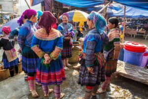
According to the 2009 census, the population of Cao Bang City was 507,183. Typical ethnic groups in Cao Bang include Tay, Nung, Dao, San Chi, Kinh, Mong, and Hoa. Which, the Thai people make up the majority of Gaoping people (about 42%), Nung people (35%), and the rest are Dao people (9.8%), Miao people (6.3%), and Kinh people (5. 5%). Notably, most of the ethnic groups in Gaoping maintain their language, which is still used in everyday life. Vietnamese today is Cao Bang’s lingua franca, and most people here can understand and communicate.
Administrative
Cao Bang consists of 1 city and 12 districts: Gaoping City, Baole District, Baolin District, Halang District, Haguang District, Hoa An District, Nguyen Binh District, Fuhe District, Guangyuan District, Ta’an District, Tongnong District, Chaling District, Zhongqing District.
Society
According to the Department of Education of Cao Bang province, as of December 31, 2011, the province has nearly 90,000 students at all levels, 365 schools (from primary to high school), and 7,790 teachers. Regarding vocational education, the province has 3 high schools with 115 teachers and 3,500 students; a college with 88 teachers and nearly 2,000 students; a vocational secondary school with more than 800 students annually. The province also focuses on improving the quality and skills of human resources to serve the province’s socioeconomic construction and development.
By 2012, the province has 312 medical facilities, including 16 hospitals, 96 district clinics, 1 nursing station, 199 dispensaries, wards, and communes; 2,339 medical staff, including 514 doctors, nurses, and technicians, 906 people, 556 housekeepers. The core positioning of the field of medical examination and treatment is to take care of people’s health, especially mothers and babies in remote and isolated areas, focusing on building and improving the capacity of medical examination and treatment, preventing and controlling diseases. diseases: malaria, goiter, tuberculosis, tetanus, child malnutrition.
Culture
Cao Bang is not only famous for white rice with clear water but also famous for its vibrant culture, the intersection of many multi-ethnic cultures. Each ethnic group has its own unique traditional cultural heritage. Most Thais live in Gaoping.
The cultural identity of the Tay people is expressed in folk songs and dances such as lion singing, then singing, dew gliding, orphaning, gliding Gann, dew dance, Chau dance, dan man, ward ly… The Nung people have many branches, distinguished by their costumes and voices: Nung Inh, Nung An, Nung Loi, Nung Giang, etc. are identical. The Nong people are famous for their fan dance, khan dance, erhu, green drum, and sea singing (300-year-old classical tuong).
The Cao Bang Taoists are industrious by nature and live mainly in the low mountains. Taoist clothing is very delicate and comes in many different forms. The Dao family in Gaoping includes two branches, Daotian and Dao Do (Red Dao). The name Daotian comes about because they decorate their clothes with silver coins, while the Hongyao people use red and blue fabrics to make their traditional clothes. The decorations on the knife cloth are extremely unique and rich, mainly the images commonly encountered in daily life such as flowers, leaves, plants, ancestors, and animals closely associated with life. These images create their nuances in Dao culture. Most of the Hmong live in high mountains and remote areas, concentrated in Baole, Babe, Tongnong, Heguang, and other places, and live nomadic lives. The H’Mong people are famous for their umbrella dance and the sound of the trumpet.
Tourism
Cao Bang, a province located on the northern border of the country, has a proud history and culture. The traditional history of Cao Bang is associated with the early history of the country’s founding and defense of the Vietnamese nation.
Referring to Cao Bang is referring to a heroic history page of Pac Bo, Tran Hung Dao Forest, Dong Khe, Lam Son… History of national heroes. Normally, Pac Bo belongs to Truong Ha commune, Ha Quang district. This is where President Ho Chi Minh lived, worked, and did revolutionary activities for national independence from 1941 to 1945. Tran Hung Dao forest is where Vietnam advertised the establishment of the People’s Liberation Army.
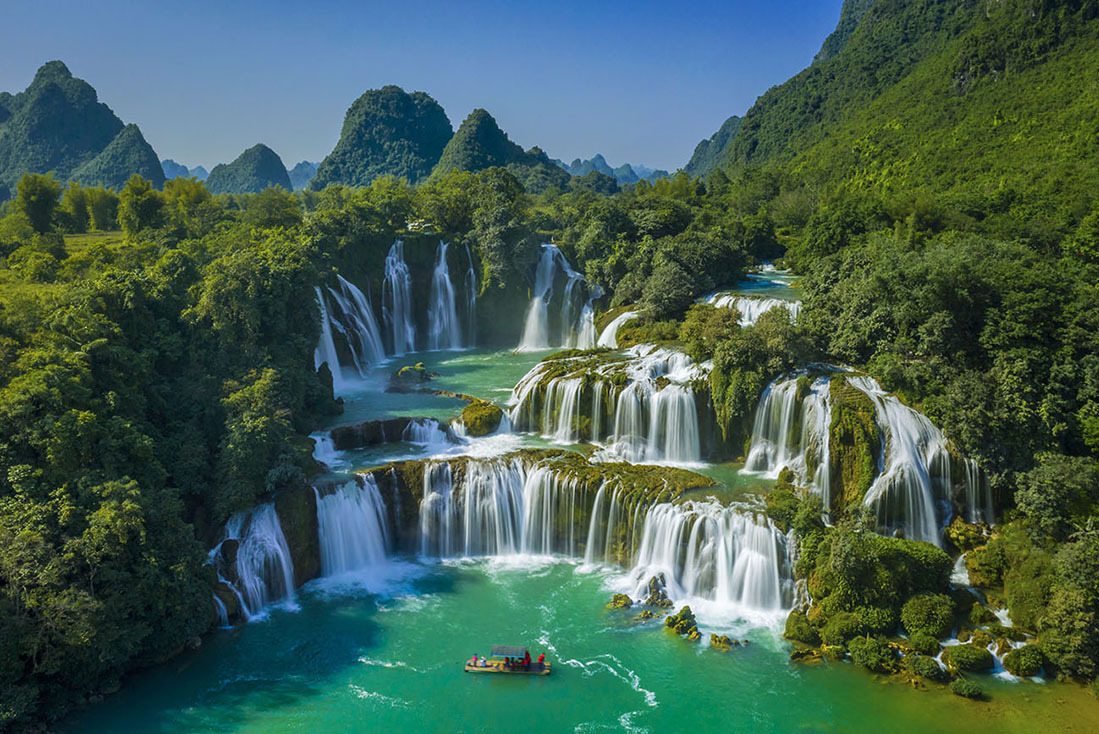
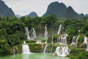
Ban Gioc Waterfall is a masterpiece of nature bestowed on Cao Bang and is considered one of the most beautiful waterfalls in Vietnam. Ban Gioc Waterfall is located in Dam Thuy commune, Trung Khanh district, about 89km from Cao Bang town, originating from Quy Son River with a height of more than 53m. The top of the waterfall is divided into three parts by rocks and trees. When the water falls from the cliffs and mixes with the sunlight, a rainbow of seven colors can be seen forming. Many trees and flowers make the air fresh in late autumn.
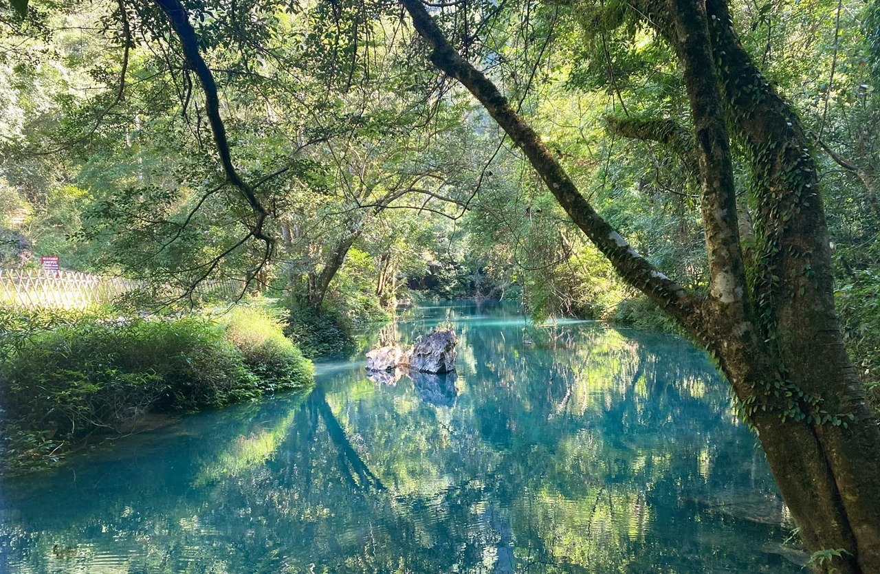
Nguom Ngao is located in the heart of limestone mountains, about 3 km from Ban Gioc waterfall, and is one of the famous caves of Cao Bang formed by the weathering process of limestone. Nguom Ngao Cave is 2144m long, quite wide, including 3 gates, the scene is like a fairyland. Stalactites sprout from all directions, intertwining into a magically complex labyrinth. Nature skillfully shapes inanimate rocks, people, trees, animals, fairies, and lotus flowers… all contain a fanciful space where rock and water blend.
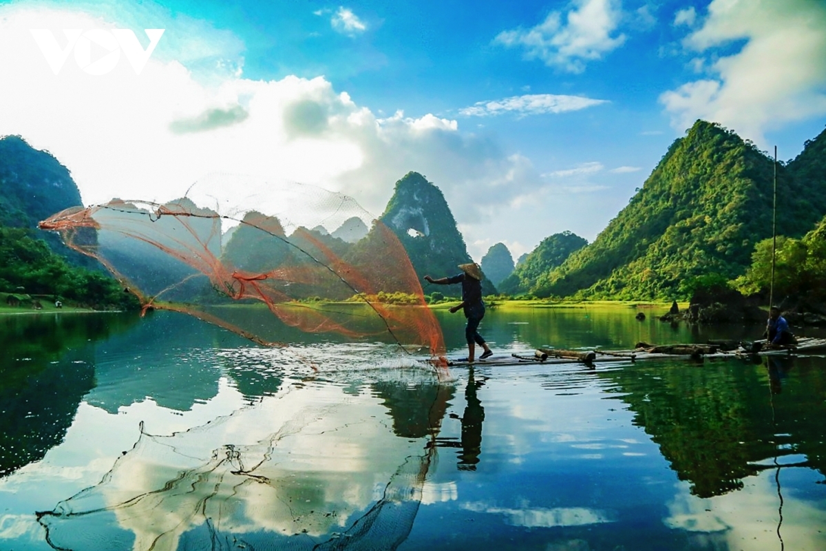
Khuoi Lai Lake has located among the hillsides in Hoi An area, Cao Bang commune. The lake is 72 hectares wide, the water is clear and gentle all year round. The poetic space of Kuile Lake is an ideal place for eco-tourism, fishing, hunting, and boating on the lake. Breathtaking natural beauty, majestic mountain scenery, and countless famous historical sites, as well as rich and colorful cultural activities, make Gaoping a tourist attraction attracting domestic and foreign tourists.
Festival
Cao Bang is a province in the Northeastern region of Vietnam with immense forests and majestic rivers. The beauty of the scenic spots and historical sites is the charm of tourists. The festival is also an intangible cultural heritage bearing Gaoping cultural identity. Each festival has its characteristics, related to the cultural characteristics of each place. For a long time, quan ho has become a form of community cultural activity and an indispensable spiritual “food” of local people. Every year, Cao Bang has many big festivals attracting a large number of locals and tourists from all over the world such as the Long Tong Festival, Ky Sam Temple, King Le Temple, Da Quan Pagoda, Nang Hai Festival, and fireworks.
The Long Tong Festival is one of the most important festivals of the Thai and Nung people, held from the 4th to the 10th day of the first lunar month. It is a festival bearing the imprint of agricultural production, from festival opening rites, and sacrifices to folk games. The Long Tong festival has a long history and is passed down from generation to generation in the Tay Nong community in the northern mountainous areas: Taiyuan, Cao Bang, Beijing, Lang Son, and some Northwest provinces.
King Le Temple is located in Den Village, Hoang Tung commune, Hoa An district. It was built on a high mountain north of Nalu city during the Li Dynasty (11th century) and was called Longzhong (Dragon Tomb). Lewang Pagoda was listed as a national cultural relic protection unit in 1995 and became the venue for festivals and cultural activities of the local people. People participate in the festival to pray for favorable weather, good crops, and abundant health, expressing the meaning of “drinking water, remember the source”. Nang Hai is a Thai festival that lasts from January to mid-March. Organizing the Nam Hai festival has a symbolic meaning, welcoming the moon mother and fairies to earth to help people in work and life.
The Cao Bang festival carries a deeply human spirit, wishing for happiness, good omens, bountiful crops, and abundance. In addition, there are festivals commemorating national heroes, and festivals showing the pure customs and customs of the nation.
In addition, festivals are also a place to exchange and preserve traditional cultural and artistic values. Singing Then, Singing Sli, Dancing Khen, Da Hai, Ha Leu… Along with sweet melodies and folk games, Cao Bang has great potential for tourism development.
Cao Bằng Tours & Itineraries
Get inspired by trips other travelers have loved
Top 10 Things Must Do In Cao Bang For Traveler 2023
Cao Bang mountain, dense forest, majestic rivers, and streams, bring many savage and primitive features.
Which Is The Best Way To Get From Hanoi To Cao Bang
Cao Bang Province is a province in the Northeast region of Vietnam. From Hanoi to
Ban Gioc Waterfall Cao Bang Province Travel Guide 2023
Have you ever wondered about finding the masterpieces of nature in Northern Vietnam? In just